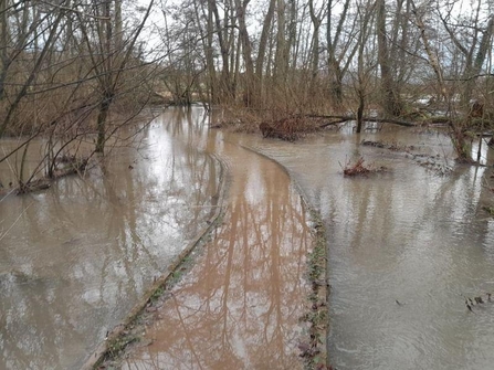
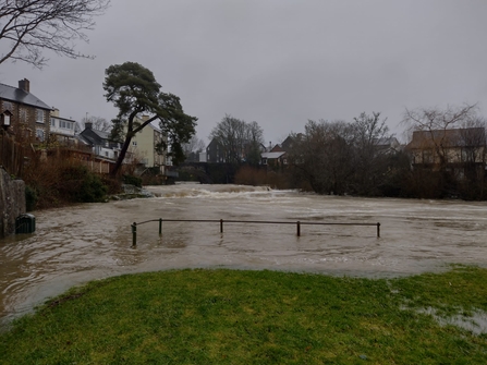
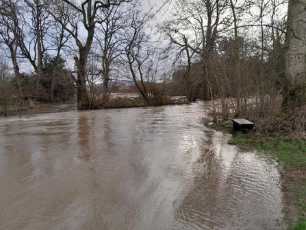
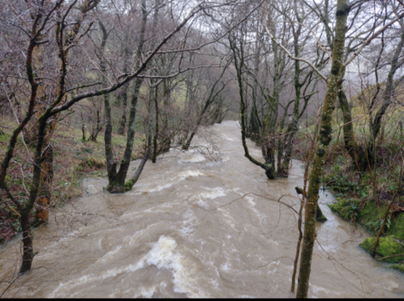
The catchment area for the Wye in Radnorshire includes some of the main tributaries such as, the Elan, Ithon, Irfon and Lugg. On the 30th of December 2023 most of the Wye catchment was issued with flood warnings due to the increased rainfall in the latter weeks of the year. This has led to an increase in flooding in Radnorshire, with towns such as Rhayader, being adversely affected. The rise in river levels has also seen a Radnorshire Wildlife Trust (RWT) site, Gilfach nature reserve, experience flooding along the River Marteg, a tributary to the Wye. In many places along the wye the rising levels have exceeded the riverbanks and spilled over into communities and agricultural land, this can lead to further pressures for the Wye and the communities in the Wye catchment in both Wales and England.
In central Radnorshire there was approximately 77.1mm more rainfall annually in the past 10 years than between 1990 and 2010. With the average number of days where it rained increased 4 days, with more than 70 days of rainfall exceeding 10mm. The annual rainfall has increased by 10 days of heavy rainfall in the past 10 years. The increase in rainfall is a result of our changing climate and has devastating impacts on local communities throughout Radnorshire and throughout the Wye catchment.
In addition, the way in which we manage the land can have an impact on the local landscape and increase the chances of flooding. Bare soil, overgrazing and over felling of trees can increase the risk of flooding in an area which is particularly liable to flooding and may result in increased soil erosion and an increase in pollution.
Sediment erosion
Soil along the banks of the Wye is eroding and carried downstream during periods of flooding, and in areas of fast flowing water. The Wye is predominantly bordered by agricultural land and some settlements. The land bordering the Wye which is for agricultural use can reduce the quality of the river during these flooding events through sedimentation and nutrient runoff. Nutrients from agricultural land such as, phosphate and nitrate leach into the water reducing the water quality and overall impacting the diversity of the Wye. In addition, the topsoil can be lost during these flooding events reducing the yield and quality of the crop or damaging pastures for grazing.
Soil health and flooding
Soil management can be imperative to mitigating the effects of flooding on agricultural land. Poor soil quality will be compact, containing little plant and wildlife biomass. The lack of aeration of the soil reduces the water infiltration and increased waterflow can run more quickly, rapidly filling the tributaries and causing flooding events. Healthy soil contains a rich biodiversity of plant matter, you can assess soil through the network of fungi throughout the soil. Soil that has had little disturbance will have a high level of fungi within it, whereas degraded soil may just possess the roots of the crop above, such as grasses from an overgrazed pasture. Healthy soil has a high infiltration rate and can absorb a higher volume of rainfall and act as a sponge, slowing the flow and reducing the level of flooding in an area.
What can we do to mitigate flooding?
Nature-based Solutions (NbS) and Natural Flood Management (NFM) can be utilised in areas at risk of flooding and can mitigate the effects of climate change. The use of these techniques can increase the resilience of the landscape and economic resilience of the communities in the Wye catchment.
Slow the flow!
The amount of water coming off the upland areas in Radnorshire can influence the effects of flooding downstream. By slowing down the speed in which water runs off the land and down tributaries can reduce the risk of flooding in the Wye catchment. We can utilise NbS and NFM such as, leaky woody dams and woodland management.
Landowners, tenants and farmers:
Land management techniques such as, regenerative agriculture can help farmers to reduce soil erosion and mitigate the effects of flooding and drought, through a variety of methods:
- Rotation grazing increases the health of the pastures and improve soil health.
- Contour farming is effective in uplands and steep slopes, it can reduce the possibility of land slides and increase ground stability.
- Agroforestry can improve soil quality and yields, whilst absorbing excess water which in turn reduces the chances of flooded roots of crops.
- Cover crops can help absorb water during intense rainfall and retain the moisture of the soil, increasing crops resilience to droughts. Cover crops help reduce soil erosion by binding the soil, reducing the time the soil is left bare between harvest and establishment of main crops. In addition, they can help retain the nitrogen in the soil, reducing nitrate pollution of river systems during heavy rainfall.
Communities
Communities in the Wye catchment face the hardship of flooding events during periods of heavy rain, with the frequency of flooding events increasing it can be devastating for those that live in high-risk areas. There are things we can do in our local communities to help the rivers and try to reduce flooding in the Wye.
- Contact those in your local community and see if there are any groups in your area trying to save the rivers.
- If there is a stream running through your garden or a small trickle flowing into your local ditches or gully’s. You could create a pond, plant some reeds and water tolerant native species. Where water is abundant and slow you can attract a wide diversity of species to your garden and local areas such as frogs and dragonflies.
- Get in touch with you local council and see what their plans are for mitigating flooding in your area and see how you can get involved.
Get involved
If you are wondering how you can get involved and help reduce the effects of flooding in the river Wye catchment area, check out the Wye Adapt to Climate Change project website. Contact the project officer and we can offer free advice and support. You can also join the Radnorshire Wildlife Trust and get updates on key projects and work we are doing to help save the local landscape. Keep an eye out for more information on new projects and funding opportunities from the Wildlife Trust to help save the Wye.